Capturing the Arctic and Antarctic
Capturing and measuring the environment in the Arctic and Antarctic is a particularly challenging job. The area of interest is often covered by a thick blanket of snow and ice,...
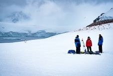
Capturing and measuring the environment in the Arctic and Antarctic is a particularly challenging job. The area of interest is often covered by a thick blanket of snow and ice,...
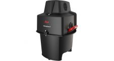
Leica Geosystems, part of Hexagon, has announced the introduction of Leica Chiroptera-5, the new high-performance airborne bathymetric Lidar sensor for coastal and inland water surveys. This latest mapping technology increases...

The U.S. Geological Survey has contracted with Woolpert to conduct a high-precision geophysical survey and subsurface geologic mapping in Arkansas. The firm will collect, process and deliver high-resolution airborne radiometric...
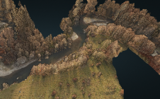
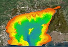
The monitoring of submerged deadwood and vegetation is gaining increased attention due to their socio-economic and ecological importance. Deadwood acts as an important underwater habitat but also poses a threat...

In this interview, Thomas Harring, president of Hexagon’s Geosystems division and CEO of Leica Geosystems, shares his thoughts on the present and future of the geospatial industry, including his views...
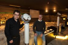
The Terra Mosana project is reinforcing the shared history in the territory where Germany, Belgium and the Netherlands meet. Today’s official country borders are relatively new, and geomatics can be...
The national land agency in Jamaica has integrated satellite-based hydrography to benefit from time efficiencies, cost savings and improved safety as part of its hydrographic programme in support of the...
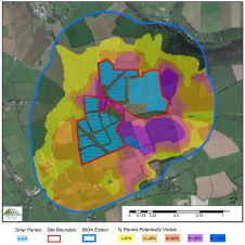
3D maps derived from the latest aerial photography are being used to secure planning permission for solar farms across the Republic of Ireland. Created by Bluesky International, the digital terrain...

In this interview, Ron Bisio, senior vice president of Trimble Geospatial, provides his views on the key market trends, technology drivers and challenges, and the impacts of COVID-19 and climate...
RIEGL has recently released its software suite for processing kinematic Lidar data: RiPROCESS 1.9.2. The software and the associated tools provide additional benefits for processing RIEGL kinematic laser scan data....
This site uses cookies. By continuing to use this website, you agree to our Cookies Policy. Agree