Somewhere Deep Inside
It is about thirty-five years since I left university with the Dutch equivalent of a MSc degree in Geodesy. Computers had just been introduced into our field and we were...
It is about thirty-five years since I left university with the Dutch equivalent of a MSc degree in Geodesy. Computers had just been introduced into our field and we were...

Intergeo 2023 was an electrifying three-day event in Berlin, transforming the city into the global geospatial capital. From 10-12 October, professionals from across the globe convened for the world’s premier...
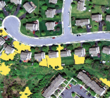
A city council in Australia has used the ENVI Deep Learning module to analyse the 3D point cloud resulting from a leaf-on airborne Lidar survey, in preparation for a tree-planting initiative....
In this article, we examine the evolving landscape of bathymetry with insights from Anders Ekelund, vice president of airborne bathymetric Lidar at Hexagon Geosystems. Beyond mapping seagrass, Ekelund unveils Lidar’s...
Woolpert has forged a strategic alliance with Allvision with the goal of enhancing geospatial artificial intelligence capabilities and applications. This partnership seamlessly integrates Pittsburgh-based geospatial analytics and asset management company...
European Space Imaging (EUSI) has recently have announced a strategic partnership giving users direct access to the world's most detailed hyperspectral imagery from Pixxel. Combined with EUSI’s capability to build...
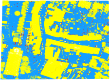
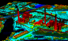
As a division of machine learning, deep learning (DL) has been achieving unparalleled success in image processing and recently demonstrated huge potential for point cloud analysis. Precise ground surface topography...

The curtains have fallen on Intergeo 2023. What were the key takeaways from the vibrant three-day event in Berlin? From 10-12 October, a diverse array of experts and enthusiasts from...
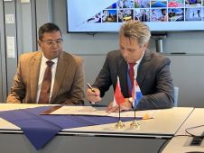
Dutch Kadaster and the Indonesian National Land Agency have signed a new Memorandum of Understanding (MoU). The two parties have been collaborating on the modernization and digitalization of land registration...

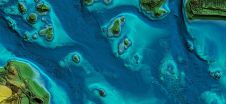
Oceans cover 71% of the surface of our planet and yet 95% of the ocean floor remains unmapped in detail. This in itself may not seem to be very important...
This site uses cookies. By continuing to use this website, you agree to our Cookies Policy. Agree