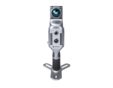
JOUAV unveils advanced airborne Lidar sensor
JOUAV has released the JoLiDAR-1000 Lidar sensor designed specifically for uncrewed aerial vehicles (UAVs or ‘drones’) as the latest addition to its array of high-performance Lidar sensors for use in...

JOUAV has released the JoLiDAR-1000 Lidar sensor designed specifically for uncrewed aerial vehicles (UAVs or ‘drones’) as the latest addition to its array of high-performance Lidar sensors for use in...

Visitor registration is now open for GEO Business, the UK's largest geospatial event. The free-to-attend expo, tailored for geospatial professionals seeking to harness the potential of location intelligence, will return...
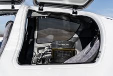
Diamond Aircraft and Vexcel Imaging have announced the next collaboration for a further expansion of Diamond’s special mission aircraft high-end sensor portfolio. The partnership will integrate the UltraCam Dragon 4.1...

The Icelandic authorities have commissioned Acecore to map the extent and aftermath of the Eldvörp-Svartsengi volcanic system eruption using its high-end drone solutions. Grindavík, a fishing village on the Reykjanes...
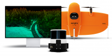
Wingtra has unveiled its innovative Lidar-drone solution. The new Lidar payload is designed to seamlessly integrate the efficiency, ease of operation, and high accuracy of the WingtraOne GEN II drones...
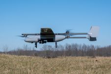
In a new strategic partnership, Inertial Labs' RESEPI Payload Lidar technology will be integrated into E38's advanced E455 drone platform. This collaboration marks a significant milestone in the utilization of...
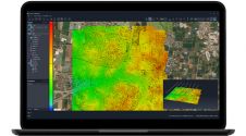
SimActive has unveiled the enhancement of Correlator3D for improved cloud environment productivity. With Correlator3D’s distributed processing capabilities, clients can seamlessly scale their processing in line with operational needs. The challenges...
Stonex has launched a new SLAM solution for fast and efficient large-area surveys: the X70GO SLAM laser scanner. It combines mobile scanning with a stationary mode to scan with higher...

Stonex is an Italian company, world leader in measurement and surveying. The head office is near Milan and the American headquarters is in Concord, USA. The company also has a...
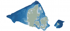
Through the collaborative implementation of satellite-derived bathymetry (SDB), the Danish Geodata Agency and EOMAP are synergizing efforts to contribute to the European Marine Observation and Data Network (EMODnet) Bathymetry partnership....
This site uses cookies. By continuing to use this website, you agree to our Cookies Policy. Agree