Earth Observation and UAVs - Imaging from the Sky
It was a pleasure getting this issue together – the theme Big Data sounds abstract and perhaps has first association with cloud computing, servers and other not-so-spatial aspects. We take...

It was a pleasure getting this issue together – the theme Big Data sounds abstract and perhaps has first association with cloud computing, servers and other not-so-spatial aspects. We take...
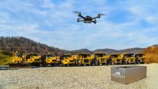
Identified Technologies, a company focused on increasing project visibility and team productivity with drones for different industries, has upgraded its Boomerang UAV solution to significantly reduce time spent on data...

4DMapper has partnered with Verity Positioning to offer Verity Cloud, an end-to-end solution for high-accuracy mapping. It offers streamlined photogrammetry processing on Autodesk Forge, a cloud developer platform, delivering unmatched...
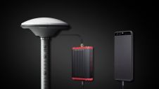
With the launch of the WingtraOne post-processed kinematic (PPK) drone, the Swiss manufacturer of unmanned aerial vehicles (UAVs or ‘drones’) Wingtra aims to set a new benchmark in large-scale surveying...
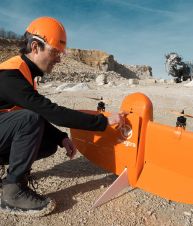
Every mapping project is unique; even within the same industry, each project will have its own distinct challenges. Selecting the right equipment is therefore key to getting the job done....
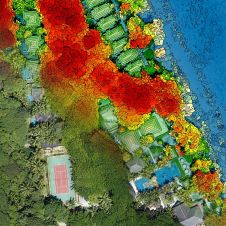
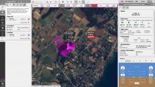
This survey in southern France confirmed the suitability of UAV Lidar for mapping shoreline changes in the context of erosion and drinking water availability. The French Mediterranean coast is a...
Tersus GNSS, a leading provider of centimetre-accuracy GNSS RTK solutions, is taking surveying applications to the next level with the global launch of Tersus David, a GNSS receiver. For surveyors,...

Viametris, a leader in mobile scanning technology, has launched its bMS3D backpack mobile scanning system embedding a 360° camera. The device is the world's first mobile scanning backpack system including...
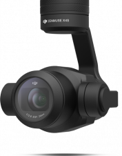
DJI has released the X4S camera, a lightweight version of the large aerial cameras carried in manned aircraft. How do aerial or metric cameras differ to a DSLR? An aerial mapping camera...
senseFly, a producer of professional mapping drones, and a Parrot Group company, has released a new version of its industry-acclaimed flight and data management software, eMotion. eMotion 3.5 includes a...
This site uses cookies. By continuing to use this website, you agree to our Cookies Policy. Agree