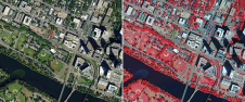
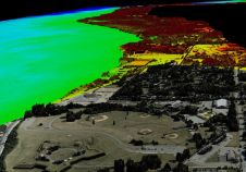
Use of AI to detect rooftop solar potential
Global climate change and, in some areas, the lack of a cheap and reliable energy supply are contributing to the expansion of photovoltaics, both regionally and worldwide. In addition to...
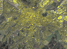
Global climate change and, in some areas, the lack of a cheap and reliable energy supply are contributing to the expansion of photovoltaics, both regionally and worldwide. In addition to...
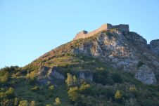
The city of Carcassonne in the south of France hopes to obtain UNESCO World Heritage certification for its sentinel mountain castles, better known as Les Châteaux Cathares. Built in the...
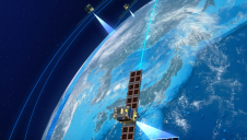
Synspective has partnered with Insight Terra to offer a new space-based monitoring solution for the mining industry. The solution combines satellite and Earth observation data with ground sensors to monitor...
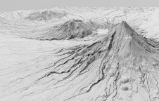
A new, high-tech aerial laser survey project has been completed in the New Zealand region of Taranaki, producing an exact 3D map of the region's land surface. The survey, conducted...
SaeHan Aero Survey has become the first customer in Korea to purchase the IGI UrbanMapper-2P. This nadir and oblique imaging system will be operated together with IGI’s LM-7802S, a high-performing...
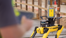
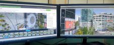
South Korean-based Hanhwa Engineering and Construction is deploying the latest innovative smart construction technology. “We are currently utilizing robot dogs with 3D scanners and augmented reality technology for the construction project...
Hexagon's Geosystems division has announced that the HxGN Content Program will refresh aerial data of eight US states at 15cm resolution for the 2023 collection season, including Texas, Washington, Florida, South Carolina,...
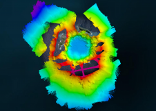
The Tonga Eruption Seabed Mapping Project (TESMaP) is a collaborative mission to discover the undersea impacts of the January 2022 eruption of the Hunga-Tonga Hunga-Ha’apai volcano. Using their collective knowledge,...
“Think big for coastal mapping” is the foremost advice that Don Ventura of Teledyne Geospatial would impress upon agencies interested in bathymetric Lidar. “It’s a matter of efficiency of scale.”...
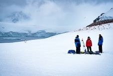
Capturing and measuring the environment in the Arctic and Antarctic is a particularly challenging job. The area of interest is often covered by a thick blanket of snow and ice,...
This site uses cookies. By continuing to use this website, you agree to our Cookies Policy. Agree