Found 71 results
Sort by

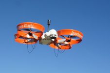
New Unmanned Aerial Photogrammetric Mapping Solution

Drone manufacturer ScientificAerospace together with mapping company DroneMetrex from Adelaide, Australia, has developed a photogrammetric mapping solution that offers new possibilities for the geospatial industry. Building on the advantages of ScientificAerospace’s experience...

Read more

Hybrid UAS/UAV: Fixed Wing and Chopper in One Aircraft

A hybrid UAS/UAV combines the best of two worlds: the benefits of a fixed wing and chopper in one aircraft. Unmanned airborne systems (UASs) – aircraft which fly without human pilots on board – have soared in popularity as surveying devices. Today they are applied in a wide variety of...

Read more

UAVs Revolutionise Land Administration

In 2014, a joint publication by the World Bank and the International Federation of Surveyors (FIG) entitled 'Fit-for-Purpose Land Administration' noted that 75 percent of the world’s population do not...

Read more

UAS for Mapping

In recent years, unmanned aerial systems (UAS) have attracted tremendous attention from surveyors and other geodata collectors all around the world. Nowadays, UAS equipped with GNSS, IMU and RGB, NIR...

Read more