Icaros Releases Aerial Oblique Image Mapping System
Icaros, a leading provider of advanced aerial remote sensing technology, has announced the release of its latest aerial remote sensing system, the Icaros Digital Mapper (IDM) 1000. The IDM 1000...
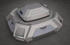
Icaros, a leading provider of advanced aerial remote sensing technology, has announced the release of its latest aerial remote sensing system, the Icaros Digital Mapper (IDM) 1000. The IDM 1000...

The year 2013 marks the 10-year anniversary of UltraCam digital photogrammetric aerial mapping systems. Since the introduction of the UltraCamD in 2003, numerous and significant technological advancements have contributed to...

Since 2009 Blom Germany have been working with SmartPlanes to develop a cost-effective light-weight UAV solution for the European market. With more than a hundred trials and now some ten...
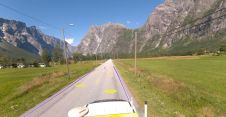
Field and Mosaic have jointly developed an advanced mobile mapping solution for road network management. Thanks to this successful collaboration, road asset managers and owners can now explore and interrogate...

Prague recently served as the testing ground for the integration of Mosaic’s 360-degree camera system with SmartDelta’s mobile mapping software. Known for its rich history and stunning architecture, the city...
Arrowhawk Imaging has selected an UltraCam Eagle Mark 3 aerial camera system with a 100mm lens as its first airborne imaging system. Since purchasing the sensor from Vexcel Imaging in...
Aerial Surveys International has purchased a second Intergraph Digital Mapping Camera to meet increasing demand from customers for high-quality digital imagery. The Intergraph DMC will be used by...

EHS Built Heritage Division wishes to take advantage of the opportunity which high definition LIDAR technology presents to assist it in its archaeological recording function. The high definition LIDAR service...
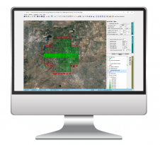
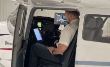
Phase One has announced its new iX Suite, a fully integrated software package for aerial mapping project management. Compatible with all Phase One PAS airborne systems, iX Suite handles mission...

Celebrating four decades as a pioneering force in the UK and Ireland's geospatial industry, Murphy Geospatial has unveiled its innovative mobile-mapping solution called GeoDrive. This groundbreaking technology enables the collection...
This site uses cookies. By continuing to use this website, you agree to our Cookies Policy. Agree