The bright side of mapping
Attendees of YellowScan's recent Lidar for Drone 2022 Conference headed home with a backpack full of inspiration, according to Wim van Wegen. A relaxed vibe, sunny weather with summer temperatures,...
Attendees of YellowScan's recent Lidar for Drone 2022 Conference headed home with a backpack full of inspiration, according to Wim van Wegen. A relaxed vibe, sunny weather with summer temperatures,...
Eloise McMinn Mitchell is a content writer at Pix4D, where she works on sharing and creating content about the use of drones and photogrammetry in all industries ranging from public...

Pix4D will be hosting its flagship conference in Denver, Colorado, on 13 October 2022. The event includes expert guest speakers on 3D modelling and photogrammetry, personal consultations, networking opportunities, the...
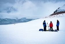
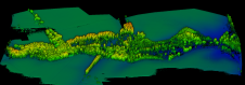
Capturing and measuring the environment in the Arctic and Antarctic is a particularly challenging job. The area of interest is often covered by a thick blanket of snow and ice,...

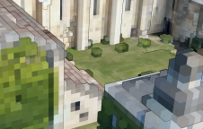
The application of visual positioning technology to geological mapping is of great significance given its current widespread use and huge potential in multiple industries. It is a significant exploration for combining GNSS, IMU, and cameras for a surveying and mapping job. Visual positioning technology can break through the bottlenecks of traditional mapping scenarios. It makes geological mapping more accurate, efficient, and diverse. The vRTK is the first GNSS receiver with dual cameras. Let's see what surprises it will bring to us in the land survey! Visual Positioning Technology is a Major Breakthrough in GNSS Receiver Development The GNSS Receiver has evolved over the years. Through continuous product improvements, a highly integrated RTK receiver with inertial...
Read this guide to the main 3D data representation methods to understand the key differences and choose the best method for your specific applications. The 3D data jungle in today’s...
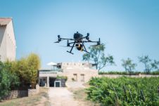
Lidar owes its growing popularity to the accuracy and high resolution with which it maps the environment. Continued technological advances are resulting in even better usability, reliability and sustainability, while...
Norman Teferle is a professor of Geodesy and Geospatial Engineering in the Faculty of Science, Technology and Medicine at the University of Luxembourg. He is well known for his contributions...

The FIG Congress 2022 marks the end of the current leadership term (2019-2022) for the president, two vice presidents and all ten commission chairs. It has been an unusual –...

Marko Marković is assistant professor at the Faculty of Technical Sciences (FTS), University of Novi Sad (UNS), Serbia. He received a PhD in geodesy from the FTS in 2018. His...
This site uses cookies. By continuing to use this website, you agree to our Cookies Policy. Agree