Signal Disruptions
GNSS… it’s almost impossible to run a modern geo-related business without it. But what if a problem should occur? Whether in navigation, surveying or even agriculture, countless activities almost ...
Positioning is the accurate determination of the location of an object in space, relative to a framework or datum. In geographic / hydrographic information positioning is always present to determine the location of whatever we are measuring.
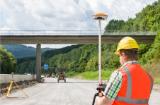
Depending on the type of application the framework can be global or local. When used globally techniques such as GNSS are used and the framework is defined by geodetical coordinate reference systems. Local positioning can be done on a jobsite such as in construction and engineering with total station but in for indoor navigation.

GNSS… it’s almost impossible to run a modern geo-related business without it. But what if a problem should occur? Whether in navigation, surveying or even agriculture, countless activities almost ...
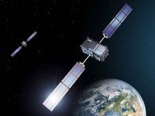
With spoofing attacks on the rise, survey-grade GNSS receivers need to be protected by interference mitigation technology utilizing the latest security techniques to ensure reliable positioning. The s...
Satellite surveying… are there any industry professionals out there not using it on (almost) a daily basis? Over the last 30 years, GNSS has become the main positioning instrument for most applicati...
Lying in one of the most tectonically active zones in the Alpine-Himalayan belt, Iran frequently suffers from heavy and disastrous earthquakes. To monitor surface displacement and measure velocity and...
Researchers at Ghent University in Belgium are using Bluetooth scanners to reconstruct the path of moving persons. Everyone with a Bluetooth-enabled phone is a participant in their research and will b...
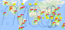
Currently there are four global navigation satellite systems (GNSSs) available: GPS, Glonass, BeiDou and Galileo. The satellites of these systems are used for positioning, and the accuracy is greatly ...

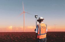
Agriculture enthusiastically absorbs geospatial technologies. Precision farming practices in particular benefit from location intelligence. The future in agriculture with geospatial applications is br...
On Tuesday 18th September 2007 at 11:35 am Pacific Daylight Time, a Boeing Delta II rocket sent a satellite weighing 2,500 kilograms into 496km sun-synchronous orbit from Vandenberg Air Force Base in...

Deformation monitoring of glaciers is of great value to scientists with an interest in climate change. Due to the slow movements of glaciers, a semi-permanent deformation system is the best method to ...

Do you need new acquisition equipment, but you're struggling to assess the alternatives? Mathias Lemmens provides some pointers to support your decision-making. When the need arises for new acquisiti...
Digitalisation and new technologies with the ability to revolutionise the geospatial industry are creating a new playing field for mapping and surveying professionals. This evolving landscape is also ...

As we head towards Brexit in 2019, satellites may be in the headlines for less than positive reasons at the moment. However, what’s clear is the universal acceptance of the value, and critical need ...
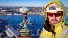
The revolutionary use of active GNSS control points and cutting-edge geomatics equipment is setting new standards for accuracy in the construction of high-rise architecture, as demonstrated by this sk...
Satellite-delivered GNSS correction services can be used in many real-time applications where real-time kinematic (RTK) and virtual reference stations (VRS) are not available. In areas without regular...

Diverse environmental effects, climatic changes and human alterations of the ecosystems are deeply changing Earth’s surface processes and creating environmental challenges that researchers are strug...
This site uses cookies. By continuing to use this website, you agree to our Cookies Policy. Agree