UAS Mapping – Where Is It Heading?
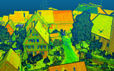
The use of a UAS to acquire geodata for mapping purposes has evolved beyond infancy and is now rapidly maturing. How will it evolve in the foreseeable future? The use of an unmanned aerial system (UAS...

Remote sensing is all about gathering information on the earth using techniques that are ‘at a distance’ rather than touching the earth. Generally speaking remote sensing produces either point cloud data or imagery. The data is further processed using [geographical information systems] as part of [cartography].
Often Remote Sensing is differentiated by the type of platform or sensor used. Platforms can range from satellites through aircraft and drones to cars and ships. From a sensor perspective, Remote Sensing is a broad field that encompasses techniques such as [photogrammetry] and [lidar] but also [echosounding]. Often a form of ground truthing is required to transform the Remotely Sensed data into comprehensible products.
The use of a UAS to acquire geodata for mapping purposes has evolved beyond infancy and is now rapidly maturing. How will it evolve in the foreseeable future? The use of an unmanned aerial system (UAS...

Images of Earth taken at night are revolutionizing our ability to measure and understand nearly every dimension related to human activity on Earth and allow us to get a glimpse into human/Earth intera...
When it comes to new-build projects, there are numerous significant pressures on delivery, whether it’s keeping to a strict budget, completing on time or even keeping all stakeholders in the loop th...

For surveyors, drones or UAVs are simply another tool in the armoury. They are platforms on which to mount sensors – camera, video, infrared, multi-spectrum etc. But for other professionals they hav...

The Netherlands’ new Quality Assurance Act means that crews may be called on to prove they are building to plan at any point. For this, teams need to have a day-by-day overview of the project situat...
What will be the impact of beyond visual line of sight (BVLOS) on the application of drones in the geospatial surveying profession? At 'GIM International', we received this question from one of our re...

What if circling the Earth were as easy as going on a bike ride? Just imagine: the extraordinary, stunning views from orbit would be accessible to everyone with the same amount of effort as cycling th...

Increased focus on cloud computing and point clouds in the construction sector is expected to result in new levels of speed, collaboration and real-time communication. The construction sector is under...

Are you thinking about using drones for land administration projects, but don't know where to start? Read on for advice from our specialists. For our ‘Ask the specialist’ features, we invite reade...

In early 2020, Hexagon announced it would be acquiring COWI’s aerial mapping business, which is known for its leading position in the European market for aerial data capture and geodata digitalizati...

How can today's advanced technology solve the challenges that many organizations face after obtaining vast 3D point cloud datasets, such as the management, storage, registration, fusion and extracti...
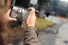
To what extent will the smartphone become a professional mapping tool? Modern smartphones already contain many of the important functions to be used as mapping tools. However, whether they are suitabl...
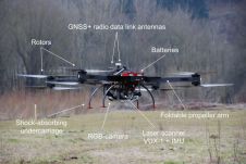
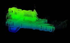
Lidar mapping based on unmanned aerial vehicles (UAVs or ‘drones’) can generally be thought of as a close-range version of manned airborne laser scanning. In brief, lower mobilization costs and mu...
In June 2018, RSPSoc's 'Photogrammetric Record' publication devoted 11 pages to determining which term they would use for drones. They ultimately decided on ‘unmanned aircraft system’ or ‘UAS’...

Aerial surveys conducted in the UK and Ireland demonstrate the potential of a combination of nadir camera, oblique cameras and a Lidar unit in one to meet the need for accurate, detailed and up-to-dat...
This site uses cookies. By continuing to use this website, you agree to our Cookies Policy. Agree