EnsoMOSAIC UAV
The most new activity in remote sensing is at the moment found in the UAV and UAS sector (Unmanned Aerial Vehicle / System). There are hundreds of companies, institutions and...
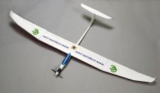
The most new activity in remote sensing is at the moment found in the UAV and UAS sector (Unmanned Aerial Vehicle / System). There are hundreds of companies, institutions and...
RapidEye's satellite system has successfully completed all post-launch testing and calibration activities, and is now ready to take on commercial operations. The satellite constellation was successfully launched in August 2008....
SBG Systems is a leading supplier of inertial motion sensing solutions, from miniature to high accuracy. Combined with cutting-edge calibration techniques and advanced embedded algorithms, SBG Systems’ products are ideal...
The eight new Technical Commission presidents elected at the ISPRS Congress in Beijing in July 2008 have set up the Working Groups that will carry out their commissions' technical programme....
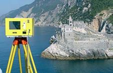
When surveying the coastline, the integration of bathymetric (below sea level) and laser scanning (above sea level) data causes problems due to the different imaging properties. However, by ensuring that...

LPS was recently selected and utilised for a significant project to create 3D models of the Acropolis in Greece. LPS is an integrated suite of photogrammetry software tools for generating...
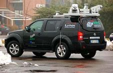
The use of Mobile Lidar systems enters the scene when large areas have to be surveyed at accuracy and resolution exceeding those available through aerial photogrammetry, and when using static...

Over the period from December 2004 to 2008 the Institut Cartogràfic de Catalunya, Spain, took nearly 200,000 digital aerial images using two Digital Mapping Cameras (DMC) to replace analogue RC30...

Changing the way people acquire, analyse, visualise and disseminate geospatial information is the ambition of Vexcel Imaging GmbH, manufacturer of UltraCam and provider of remote-sensing technologies. Based in Graz, Austria,...
The mathematics a surveyor needs to calculate from measurement-derived quantities such as coordinates, distances, areas and volumes, are taught at length in secondary school, and most people will understand the...
This site uses cookies. By continuing to use this website, you agree to our Cookies Policy. Agree