Looking back on Intergeo 2023: mapping success in Berlin
The curtains have fallen on Intergeo 2023. What were the key takeaways from the vibrant three-day event in Berlin? From 10-12 October, a diverse array of experts and enthusiasts from...

The curtains have fallen on Intergeo 2023. What were the key takeaways from the vibrant three-day event in Berlin? From 10-12 October, a diverse array of experts and enthusiasts from...

Orbit GT and Vexcel Imaging has showcased an integrated solution for Aerial Oblique and streetlevel Mobile Mapping data, operational within ArcOnline, at Esri User Conference. “We’ve been supporting Oblique Imagery...

What are the challenges of image-based data acquisition for photogrammetric mapping and mesh modelling? And how can photogrammetry be made accessible? The annual Open Day Photogrammetry provided some answers to...
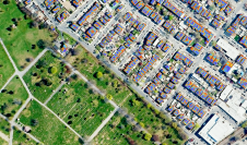
What are the primary technical differences between crewed and uncrewed aerial vehicles and satellites when it comes to capturing images of Earth? Where do they overlap, and where do they...
Webinar Vexcel
Vexcel webinar

Vexcel Imaging has released the new UltraCam Eagle 4.1, aimed at increasing flight efficiency at truly mapping-grade image quality for precise analysis and interpretation. The company itself describes this solution...
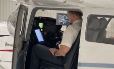
Arrowhawk Imaging has selected an UltraCam Eagle Mark 3 aerial camera system with a 100mm lens as its first airborne imaging system. Since purchasing the sensor from Vexcel Imaging in...

The role of aerial surveying in the technological response to challenges such as the global pandemic, climate change and societal issues was discussed at the EAASI Partners Summit in Malaga,...
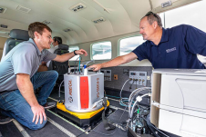
95West Aerial Mapping has completed integration and training, finalizing the delivery of RIEGL VQ-1560 II-S airborne laser scanners. The new Lidar system, with its doubled laser power and high pulse frequency, is...
This site uses cookies. By continuing to use this website, you agree to our Cookies Policy. Agree