Point-cloud Preservation Plans
The first step in the preservation of monuments and historic buildings is to completely survey and map the target; this is followed by digitised documentation for future research, reference or...

The first step in the preservation of monuments and historic buildings is to completely survey and map the target; this is followed by digitised documentation for future research, reference or...
Leica Geosystems announces the exclusive distribution of RealityLINx Model 5.4 - powered by Leica point cloud Engine (pcE) technology. RealityLINx Model 5.4 speeds and simplifies the processing of as-built laser...
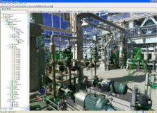
Leica CloudWorx-VR for 3ds Max, 3ds Max design, and Maya are plug-ins providing a convenient way for professionals to efficiently create more photorealistic and compelling models, renderings, and animations based...
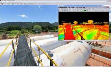
Leica Geosystems announces major releases of its flagship point cloud software applications: Cyclone 6.0; CloudWorx 4.0; and TruView 2.0. All applications now include intuitive, panoramic viewing of point clouds plus...
Land Information New Zealand has made 20TB of aerial imagery available for free for the first time in a cloud-optimized format on Amazon Web Services (AWS), making it easier and...

JOUAV has released the JoLiDAR-1000 Lidar sensor designed specifically for uncrewed aerial vehicles (UAVs or ‘drones’) as the latest addition to its array of high-performance Lidar sensors for use in...

Visitor registration is now open for GEO Business, the UK's largest geospatial event. The free-to-attend expo, tailored for geospatial professionals seeking to harness the potential of location intelligence, will return...

A topobathymetric Lidar survey was conducted to support flood preparedness in Canada. Which techniques achieved exceptional precision, and what were the logistical challenges? Find out more in this article. As...

Sven Cowan is NV5 Geospatial’s Programme Manager for Canada. He has over 20 years of experience in customer-facing positions within the geospatial information industry and has worked for multiple geospatial...
Read this guide to the main 3D data representation methods to understand the key differences and choose the best method for your specific applications. The 3D data jungle in today’s...
This site uses cookies. By continuing to use this website, you agree to our Cookies Policy. Agree