Ferdinand Vettermann
Dr Ferdinand Vettermann holds a PhD in Geoinformatics and is a cognitive solutions engineer at the German geointelligence company Deeeper.technology. As an expert in geoinformatics, he is responsible for linking...

Dr Ferdinand Vettermann holds a PhD in Geoinformatics and is a cognitive solutions engineer at the German geointelligence company Deeeper.technology. As an expert in geoinformatics, he is responsible for linking...
Innovative methodologies based on artificial intelligence (AI) are lowering the barriers and democratizing the use of 3D digital twins in the geospatial industry. Digital twins are revolutionizing the geospatial industry,...

The Open Geospatial Consortium (OGC) membership seeks to form a new Land Administration Domain Model (LADM) Standards Working Group (SWG). Public comment is sought on its draft Charter. Comments are...

Blue Marble Geographic’s flagship software, Global Mapper Pro, is an all-in-one GIS package for analysing and processing vector, terrain, image and point cloud data. Compatible with over 380 different file...
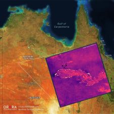
UP42 and OroraTech have signed a partnership agreement to grant easy and fast access to global high-resolution thermal-infrared imagery. UP42 is a geospatial developer platform and marketplace, and OroraTech is...

Kristen Maglia is senior product marketing manager at Esri. She started her marketing career in imagery analysis software immediately after graduating from Colorado State University, and has had the unique...

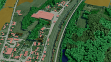
Both vertical and oblique aerial images have their own advantages, making them valuable in different reality mapping applications. So how can you choose between the two? This comparison will help...
It can still be difficult to achieve centimetre-level accuracy in mobile mapping, especially in GNSS-denied or challenging areas such as in deep urban canyons, under foliage or through tunnels. However,...
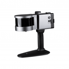
ComNav has announced the launch of its latest innovation: the LS300 3D laser scanner. This addition to the company's product lineup signifies a significant leap forward in addressing the dynamic...

Recently unveiled by Vexcel Imaging, the groundbreaking UltraCam Dragon 4.1 represents one of the market's most advanced, progressively designed and seamlessly integrated hybrid aerial mapping systems. Tailored for high-resolution mapping...
This site uses cookies. By continuing to use this website, you agree to our Cookies Policy. Agree