
The many different faces of Lidar-based survey methods
This selection of articles highlights the diversity of Lidar as a flexible tool for surveying and mapping professionals. Thanks to sensor miniaturization, laser technology is available in many different guises nowadays. From backpacks to handheld scanners and from drones to helmets, this type of remote sensing technology can be mounted on almost any device imaginable, resulting in a wide variety of data capture applications.
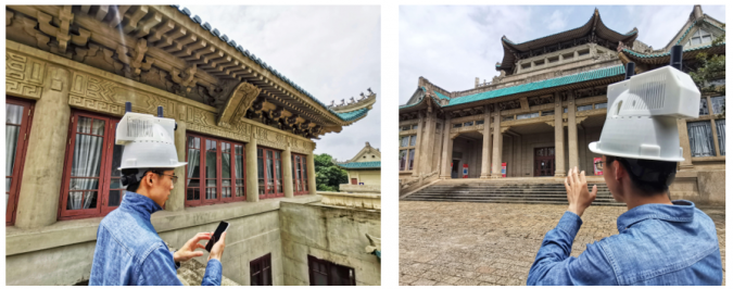
Capturing the environment with a Lidar-equipped helmet
The Dynamic Mapping Group at LIESMARS, Wuhan University in China, has designed and implemented a compact wearable mobile mapping system called the WHU-Helmet to explore the next generation of mobile laser scanning mapping.
With the development of UAVs and robotics, lightweight, low-cost and flexible mobile laser scanning systems are moving into the mainstream. However, UAV/robotics-based mobile laser scanning systems have limited capabilities in difficult environments (e.g. GNSS-denied areas and construction sites). The benefits of wearable mobile laser scanning systems include low cost, miniaturization, flexibility and the integration of wireless communication (e.g. 5G), which is why these systems represent the next generation mobile laser scanning. The Dynamic Mapping Group at LIESMARS, Wuhan University in China, led by Prof Bisheng Yang, has designed and implemented the WHU-Helmet – a compact wearable mobile mapping system – to explore the next generation of mobile laser scanning mapping.
Lidar in a backpack: scanning a whole stadium in just a few minutes
Startup Sonarski’s Lidar backpack has been used to digitally map Galgenwaard Stadium, home to the Dutch football club FC Utrecht. Read on for more details of this time-saving and convenient digital mapping solution.
As GIM International readers know, Lidar technology uses laser pulses to determine the distance to an object or surface. This method offers countless possibilities in geomatics as it enables the rapid creation of digital 3D models of large-scale structures – such as stadiums, as demonstrated in the Galgenwaard Stadium project. Work that would normally take weeks can now be completed in as little as five minutes; just one walk through the stadium results in a comprehensive digital representation of the surroundings in 3D, capturing detailed information efficiently and overlooking nothing.

Automated mobile system for mapping mine shafts
Read about this automated mobile laser scanning system developed for mining. It facilitates fast and precise measurements to produce a 3D model of the mine shaft for further analysis.
Mine shafts are governed by special rules, often difficult to access and known for their unfavourable conditions for measurements. A mine shaft is of strategic importance for the proper functioning of the mine in terms of air ventilation, transport of people and material extraction, for example. Therefore, not least for safety reasons, mine shafts require regular inspections and surveys. For this purpose, the company SKALA 3D has developed an automated mobile laser scanning system as a mining survey system (MSS) which facilitates fast and precise measurements. The result is a comprehensive 3D model of the mine shaft ready for further analysis.
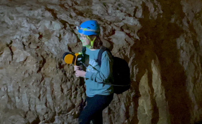
Portable Lidar mapping to capture historic cave
A professor and undergraduate students from James Madison University have geospatially scanned the oldest show cave in the USA, Grand Caverns in Virginia, and digitally mapped the largest room in 3D for the very first time.
Open to the public since 1806, Grand Caverns has been a tourist attraction for more than two centuries. The show cave boasts geographic beauty, extensive nature trails in the surrounding area and forms part of Virginia’s rich history. 3D mapping the site marks the start of another chapter in the cavern’s future.
Using GeoSLAM’s handheld ZEB Horizon scanner, geology and environmental science assistant professor Angel A. Garcia Jr from James Madison University (JMU) in Harrisonburg, Virginia, has led a team of students in creating a digital map of the historic cave rooms. With a collection rate of 300,000 points per second, an accuracy of up to 6mm and the ability to scan data with a range capacity of 100m, the ZEB Horizon captured a detailed 3D point cloud of the entire system of caves in just over 12 minutes.
Using UAV-Lidar for operational forest management
A case study from Routescene demonstrates the value of UAV-Lidar point cloud data for operational forest management. Traditionally, gathering metrics and information for forest management has been undertaken using airborne photogrammetry or by manually walking the site. More recently, airborne Lidar has been recognized as a useful tool and drone-derived Lidar data is now proving its significant worth to monitor and manage the health and value of a forest.
The project, performed across a 44,256-square-metre wooded site in Barnsley, UK, proved the advantages of using high-density UAV-Lidar data. The highly detailed dataset contained a total of 8,912,679 points enabling algorithms to be applied directly to the point cloud; this allowed the team to profile the site to individual tree level and extract pertinent metrics easily. In comparison, with lower-density datasets individual tree profiling is typically extracted indirectly in a two-step process and less accurately. Profiling to an individual tree level can be particularly useful in variable heterogeneous forest environments such as this site, to establish the structural complexity, its resilience and adaptability, to inform the management required.

Value staying current with geomatics?
Stay on the map with our expertly curated newsletters.
We provide educational insights, industry updates, and inspiring stories to help you learn, grow, and reach your full potential in your field. Don't miss out - subscribe today and ensure you're always informed, educated, and inspired.
Choose your newsletter(s)


