In land surveying the exact position and shape of objects on the surface of the earth is mapped. Included in the position is the height of an object. Techniques used are for example the total station, level instrument and GNSS. There is a direct relation between modern Remote Sensing techniques and land surveying and topography and often they are used side by side with land survey techniques providing highly accurate coordinates and remote sensing providing a broader overview. In traditional land surveying and topography objects are located in x,y and z with the addition of an object type. However, nowadays more and more attribute information is collected as well allowing detailed databases and products to be developed in cartography.

An important application for land surveying and topography is in construction and engineering but also in for example land and water management. Where land surveying and topography is about the visible objects on the earth surface, marine surveying and bathymetry is concerned with the objects under the water surface.

How 3D scanning rebuilds crime scenes for courtrooms

How 3D scanning rebuilds crime scenes for courtrooms

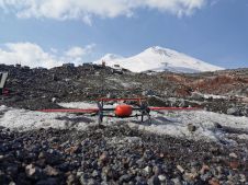
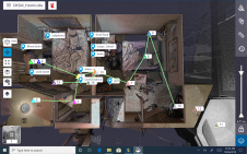
The use of 3D laser scanners is expanding the role of geospatial technology in criminal investigations. The technology is being used to produce accurate, feature-rich visualizations of crime scenes th...

Measuring Open Pit Mines

Measuring Open Pit Mines

Terrestrial laser scanning enables the acquisition of massive amounts of geo-referenced spatial data in a fraction of the time required by traditional methods. The remote scanning positions also impro...

Surveying in the Mining Sector

Surveying in the Mining Sector

What is the current status of surveying in the mining industry, and which types of survey equipment and technologies are being used today? Geospatial data forms the foundation of mining. The rapidly e...

Tandem for 3D Corridor Mapping

Tandem for 3D Corridor Mapping

3D mapping of roads, pipelines and other linear structures – often called corridors – is an important geomatics activity. Geodata acquisition technologies, which are increasingly used for corridor...

NSDI in Cambodia

Spatial information is essential for sustainable development. In developing countries land management is often hindered by the absence of national spatial-information policy, guidelines for metadata m...

Mapping the Maldives

Photogrammetry was already in existence more than a century ago, although, judging by current standards, only in its infancy. This technology, gradually refined over time and now ripened into maturit...

Partnerships and people in the surveying community

Partnerships and people in the surveying community

Less than six months into her term of office, 'GIM International' spoke to Diane Dumashie, president of FIG (2023-2026), to hear about her experiences so far. Here, she shares her perspectives on a ke...

Navigating the geospatial frontier

Navigating the geospatial frontier

In this exclusive interview, two of the driving forces behind this year's Intergeo talk about the event's evolution and impact, nurturing talent, land surveying, Earth observation and the Blue Economy...

UAS Experiences in Africa

UAS Experiences in Africa

When conducting surveys in countries near the equator, environmental conditions can be harsh. Heat, dust and humidity may disrupt sensitive equipment, while distrustful locals may obstruct the underta...

Fair Treatment of Property Rights

Fair Treatment of Property Rights

How is it possible that so many poor, vulnerable people and small farmers are the ones to suffer when their land is grabbed by the state, large investors or local elites? Doesn’t the Universal Decla...

Some human thoughts on artificial intelligence

Some human thoughts on artificial intelligence

As AI increasingly becomes a vital element in today's mapping solutions, Wim van Wegen ponders its transformative power for our industry, and the prospect of it evolving into artificial consciousness ...