Predicting the future by mapping the past
Lidar change detection (LCD) is one of the most capable techniques for mapping changing terrain through time. It can be applied in billion-dollar decisions to design, build and operate tunnels, bridge...

Remote sensing is all about gathering information on the earth using techniques that are ‘at a distance’ rather than touching the earth. Generally speaking remote sensing produces either point cloud data or imagery. The data is further processed using [geographical information systems] as part of [cartography].
Often Remote Sensing is differentiated by the type of platform or sensor used. Platforms can range from satellites through aircraft and drones to cars and ships. From a sensor perspective, Remote Sensing is a broad field that encompasses techniques such as [photogrammetry] and [lidar] but also [echosounding]. Often a form of ground truthing is required to transform the Remotely Sensed data into comprehensible products.
Lidar change detection (LCD) is one of the most capable techniques for mapping changing terrain through time. It can be applied in billion-dollar decisions to design, build and operate tunnels, bridge...
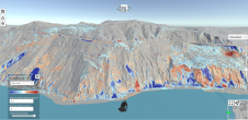
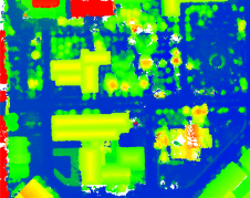
This study in Malaysia explores the use of sensor-acquired 3D point clouds as the basis for high-quality visualizations for the smart city subsurface. 3D city models are used as the underlying base fo...
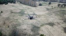
The arrival of unmanned aerial vehicles (UAVs or ‘drones’) has democratized the Lidar market forever. Everyday projects can be flown easier and faster, and sensors are getting lighter, more accura...
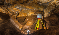
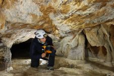
TLS and SfM photogrammetry have been used for the geodetic surveying and 3D mapping of the Ochtiná Aragonite Cave in Slovakia. This world-famous karst landscape of significant geological, geomorpholo...
The use of UAV-Lidar is being tested in the complex terrain of the Chernobyl Exclusion Zone. The aim of the University of Bristol team is to demonstrate that, in the event of a nuclear incident, it co...
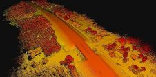
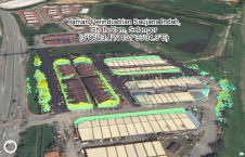
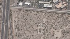
With a total length of 2,789km, the Trans-Sumatra Toll Road Project is one of Indonesia’s National Strategic Projects and the longest toll road project in Southeast Asia. In order to keep the projec...

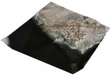
An unprecedented scientific effort to Lidar-scan the entire surface of the Earth before it’s too late... that’s how Christopher Fisher, the founder of the Earth Archive, describes his initiative. ...
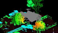
Airborne Lidar and 3D modelling technologies were used at the historic site of Fort Anne in Nova Scotia, Canada, not only as an aesthetic recreation of history, but also to help scientists decide wher...
Geospatial mapping specialists and technology from GeoSLAM have been involved in a project to map the Lombrives cave in southern France. The Human Adaption Institute conducted a pioneering isolation e...
A new basemap combines 360-degree aerial imagery and precise location data, providing an immersive new way to view and experience the built world from every cardinal direction. Basemap imagery offerin...
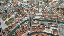
In orthophoto projects of dense urban areas, true orthophotos are preferred over traditional orthophotos because they put building roofs into the correct horizontal position. However, there is still a...
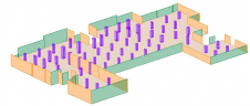
A new algorithm has been developed that automatically identifies architectural elements and creates 3D models of building interiors. Over the last decade, the demand for digital twins has increased in...
RIEGL tested the performance of its topobathymetric airborne laser scanning system in a transition zone context along the French Mediterranean coast. Initially planned as a UAV survey, tests were cond...

As the demand for elevation data continues to rise, it is important that users match the level of reliability, accuracy and resolution of the data to their specific application to arrive at an appropr...
DJI recently introduced the P4 multispectral, a high-precision unmanned aerial vehicle (UAV or ‘drone’) which exploits the integration of multispectral cameras to facilitate agricultural and envir...
This site uses cookies. By continuing to use this website, you agree to our Cookies Policy. Agree