Representing 3D point cloud data
Read this guide to the main 3D data representation methods to understand the key differences and choose the best method for your specific applications. The 3D data jungle in today’s computerized eco...
An extensive archive of all articles published on GIM International

Read this guide to the main 3D data representation methods to understand the key differences and choose the best method for your specific applications. The 3D data jungle in today’s computerized eco...
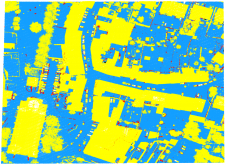
As a division of machine learning, deep learning (DL) has been achieving unparalleled success in image processing and recently demonstrated huge potential for point cloud analysis. Precise ground surf...
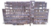
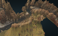
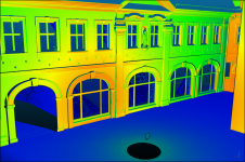
Terrestrial laser scanning is becoming increasingly important as the software and technology-related developments in many spheres of society mean that ever-higher standards are being set in terms of q...

“If everybody lived like people in the Netherlands, we would need 3.6 Earths. It would take 7.3 Netherlands to regenerate everything the country’s residents demand from nature,” according to the...
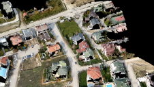
When it comes to monitoring the condition of roads, UAV technology can overcome many of the downsides associated with traditional methods, which can be time-consuming, labour-intensive and sometimes s...
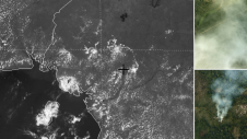
A dynamic field of view feature was used to overcome the inability of Lidar laser beams to penetrate persistent cloud cover in this project in Cameroon. In Lidar surveys, minimizing flight time is the...
The monitoring of submerged deadwood and vegetation is gaining increased attention due to their socio-economic and ecological importance. Deadwood acts as an important underwater habitat but also pose...
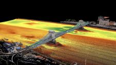
Two Hungarian companies designed a three-step data collection workflow to overcome the challenges in this urban surveying project in Hungary, which included the use of UAVs and remote-controlled boats...

In this interview, Thomas Harring, president of Hexagon’s Geosystems division and CEO of Leica Geosystems, shares his thoughts on the present and future of the geospatial industry, including his vie...
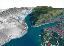
Integrated airborne sensing combining imagery and Lidar data presented an effective solution in this complex project to model two iconic Croatian cities with challenging relief and landscape. Nowadays...
What is the current state of GNSS, from both a constellation, augmentation and receiver perspective? Spoiler alert: it is more of an evolution than a revolution! It is almost impossible to imagine geo...
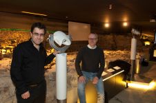
The Terra Mosana project is reinforcing the shared history in the territory where Germany, Belgium and the Netherlands meet. Today’s official country borders are relatively new, and geomatics can be...
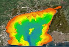
The national land agency in Jamaica has integrated satellite-based hydrography to benefit from time efficiencies, cost savings and improved safety as part of its hydrographic programme in support of t...
The VRscan3D project has developed a virtual terrestrial laser scanner simulator as a training tool to support the learning of laser scanning processes. It is intended for use by universities and othe...
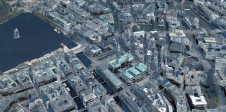
The German Federal Agency for Cartography and Geodesy (BKG) is creating a digital twin of the whole of Germany that can be used to simulate various future scenarios in order to adequately address soci...
This site uses cookies. By continuing to use this website, you agree to our Cookies Policy. Agree